A collection of maps showing changing historical boundaries and ethnic cleansing in Palestine, with comparisons to America and South Africa.
- Disappearing Palestine, Juan Cole, March 16, 2010
- Maps: Loss of Land, Palestine Portal, January 16, 2017
- Ten Maps to Understand the Occupied West Bank, Al Jazeera, 16 Sep 2024
Check out “Resources > Topics” and the other headings in the menu (☰) above.
Disappearing Palestine

Juan Cole, Informed Comment, March 16, 2010
On March 10, I posted on the humiliation heaped on Vice President Joe Biden by the Israeli government of far-right Likud leader Binyamin Netanyahu. Biden went to Israel intending to help kick off indirect negotiations between Netanyahu and Palestine Authority president Mahmoud Abbas. Biden had no sooner arrived than the Israelis announced that they would build 1600 new households on Palestinian territory that they had unilaterally annexed to Jerusalem. Since expanding Israeli colonization of Palestinian land had been the sticking point causing Abbas to refuse to engage in negotiations, and, indeed, to threaten to resign, this step was sure to scuttle the very talks Biden had come to inaugurate. And it did.
The tiff between the US and Israel is less important that the worrisome growth of tension between Palestinians and Israelis as the Israelis have claimed more and more sites sacred to the Palestinians as well. There is talk of a third Intifada or Palestinian uprising.
As part of my original posting, I mirrored a map of modern Palestinian history that has the virtue of showing graphically what has happened to the Palestinians politically and territorially in the past century.
Andrew Sullivan then mirrored the map from my site, which set off a lot of thunder and noise among anti-Palestinian writers like Jeffrey Goldberg of the Atlantic, but shed very little light.
The map is useful and accurate. It begins by showing the British Mandate of Palestine as of the mid-1920s. The British conquered the Ottoman districts that came to be the Mandate during World War I (the Ottoman sultan threw in with Austria and Germany against Britain, France and Russia, mainly out of fear of Russia).
But because of the rise of the League of Nations and the influence of President Woodrow Wilson’s ideas about self-determination, Britain and France could not decently simply make their new, previously Ottoman territories into mere colonies. The League of Nations awarded them “Mandates.” Britain got Palestine, France got Syria (which it made into Syria and Lebanon), Britain got Iraq.
The League of Nations Covenant spelled out what a Class A Mandate (i.e. territory that had been Ottoman) was:
“Article 22. Certain communities formerly belonging to the Turkish Empire have reached a stage of development where their existence as independent nations can be provisionally recognised subject to the rendering of administrative advice and assistance by a Mandatory [i.e., a Western power] until such time as they are able to stand alone. The wishes of these communities must be a principal consideration in the selection of the Mandatory.”
That is, the purpose of the later British Mandate of Palestine, of the French Mandate of Syria, of the British Mandate of Iraq, was to ‘render administrative advice and assistance” to these peoples in preparation for their becoming independent states, an achievement that they were recognized as not far from attaining. The Covenant was written before the actual Mandates were established, but Palestine was a Class A Mandate and so the language of the Covenant was applicable to it. The territory that formed the British Mandate of Iraq was the same territory that became independent Iraq, and the same could have been expected of the British Mandate of Palestine. (Even class B Mandates like Togo have become nation-states, but the poor Palestinians are just stateless prisoners in colonial cantons).
The first map thus shows what the League of Nations imagined would become the state of Palestine. The economist published an odd assertion that the Negev Desert was ’empty’ and should not have been shown in the first map. But it wasn’t and isn’t empty; Palestinian Bedouin live there, and they and the desert were recognized by the League of Nations as belonging to the Mandate of Palestine, a state-in-training. The Mandate of Palestine also had a charge to allow for the establishment of a ‘homeland’ in Palestine for Jews (because of the 1917 Balfour Declaration), but nobody among League of Nations officialdom at that time imagined it would be a whole and competing territorial state. There was no prospect of more than a few tens of thousands of Jews settling in Palestine, as of the mid-1920s. (They are shown in white on the first map, refuting those who mysteriously complained that the maps alternated between showing sovereignty and showing population). As late as the 1939 British White Paper, British officials imagined that the Mandate would emerge as an independent Palestinian state within 10 years.
In 1851, there had been 327,000 Palestinians (yes, the word ‘Filistin’ was current then) and other non-Jews, and only 13,000 Jews. In 1925, after decades of determined Jewish immigration, there were a little over 100,000 Jews, and there were 765,000 mostly Palestinian non-Jews in the British Mandate of Palestine. For historical demography of this area, see Justin McCarthy’s painstaking calculations; it is not true, as sometimes is claimed, that we cannot know anything about population figures in this region. See also his journal article, reprinted at this site. The Palestinian population grew because of rapid population growth, not in-migration, which was minor. The common allegation that Jerusalem had a Jewish majority at some point in the 19th century is meaningless. Jerusalem was a small town in 1851, and many pious or indigent elderly Jews from Eastern Europe and elsewhere retired there because of charities that would support them. In 1851, Jews were only about 4% of the population of the territory that became the British Mandate of Palestine some 70 years later. And, there had been few adherents of Judaism, just a few thousand, from the time most Jews in Palestine adopted Christianity and Islam in the first millennium CE all the way until the 20th century. In the British Mandate of Palestine, the district of Jerusalem was largely Palestinian.
The rise of the Nazis in the 1930s impelled massive Jewish emigration to Palestine, so by 1940 there were over 400,000 Jews there amid over a million Palestinians.
The second map shows the United Nations partition plan of 1947, which awarded Jews (who only then owned about 6% of Palestinian land) a substantial state alongside a much reduced Palestine. Although apologists for the Zionist movement say that the Zionists accepted this partition plan and the Arabs rejected it, that is not entirely true. Zionist leader David Ben Gurion noted in his diary when Israel was established that when the US had been formed, no document set out its territorial extent, implying that the same was true of Israel. We know that Ben Gurion was an Israeli expansionist who fully intended to annex more land to Israel, and by 1956 he attempted to add the Sinai and would have liked southern Lebanon. So the Zionist “acceptance” of the UN partition plan did not mean very much beyond a happiness that their initial starting point was much better than their actual land ownership had given them any right to expect.
The third map shows the status quo after the Israeli-Palestinian civil war of 1947-1948. It is not true that the entire Arab League attacked the Jewish community in Palestine or later Israel on behalf of the Palestinians. As Avi Shlaim has shown, Jordan had made an understanding with the Zionist leadership that it would grab the West Bank, and its troops did not mount a campaign in the territory awarded to Israel by the UN. Egypt grabbed Gaza and then tried to grab the Negev Desert, with a few thousand badly trained and equipped troops, but was defeated by the nascent Israeli army. Few other Arab states sent any significant number of troops. The total number of troops on the Arab side actually on the ground was about equal to those of the Zionist forces, and the Zionists had more esprit de corps and better weaponry.
The final map shows the situation today, which springs from the Israeli occupation of Gaza and the West Bank in 1967 and then the decision of the Israelis to colonize the West Bank intensively (a process that is illegal in the law of war concerning occupied populations).
There is nothing inaccurate about the maps at all, historically. Goldberg maintained that the Palestinians’ ‘original sin’ was rejecting the 1947 UN partition plan. But since Ben Gurion and other expansionists went on to grab more territory later in history, it is not clear that the Palestinians could have avoided being occupied even if they had given away willingly so much of their country in 1947. The first original sin was the contradictory and feckless pledge by the British to sponsor Jewish immigration into their Mandate in Palestine, which they wickedly and fantastically promised would never inconvenience the Palestinians in any way. It was the same kind of original sin as the French policy of sponsoring a million colons in French Algeria, or the French attempt to create a Christian-dominated Lebanon where the Christians would be privileged by French policy. The second original sin was the refusal of the United States to allow Jews to immigrate in the 1930s and early 1940s, which forced them to go to Palestine to escape the monstrous, mass-murdering Nazis.
The map attracted so much ire and controversy not because it is inaccurate but because it clearly shows what has been done to the Palestinians, which the League of Nations had recognized as not far from achieving statehood in its Covenant. Their statehood and their territory has been taken from them, and they have been left stateless, without citizenship and therefore without basic civil and human rights. The map makes it easy to see this process. The map had to be stigmatized and made taboo. But even if that marginalization of an image could be accomplished, the squalid reality of Palestinian statelessness would remain, and the children of Gaza would still be being malnourished by the deliberate Israeli policy of blockading civilians. The map just points to a powerful reality; banishing the map does not change that reality.
Goldberg, according to Spencer Ackerman, says that he will stop replying to Andrew Sullivan, for which Ackerman is grateful, since, he implies, Goldberg is a propagandistic hack who loves to promote wars on flimsy pretenses. Matthew Yglesias also has some fun at Goldberg’s expense.
People like Goldberg never tell us what they expect to happen to the Palestinians in the near and medium future. They don’t seem to understand that the status quo is untenable. They are like militant ostriches, hiding their heads in the sand while lashing out with their hind talons at anyone who stares clear-eyed at the problem, characterizing us as bigots. As if that old calumny has any purchase for anyone who knows something serious about the actual views of Israeli Prime Minister Binyamin Netanyahu or Foreign Minister Avigdor Lieberman, more bigoted persons than whom would be difficult to find. Indeed, some of Israel’s current problems with Brazil come out of Lieberman’s visit there last summer; I was in Rio then and remember the distaste with which the multi-cultural, multi-racial Brazilians viewed Lieberman, whom some openly called a racist.

Maps: Loss of Land
PalestinePortal.org, January 16, 2017
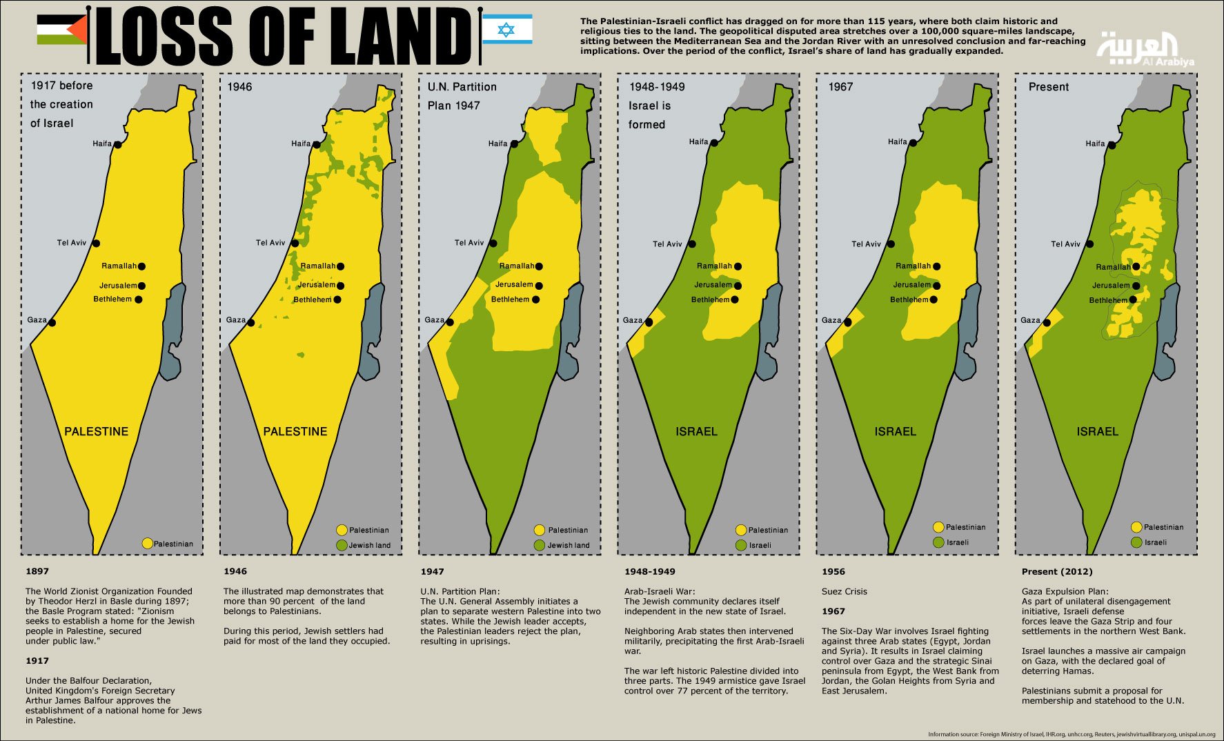
Above: A more detailed Loss of Land series of maps, with some brief information on the events leading to each change of borders. See a larger view here.
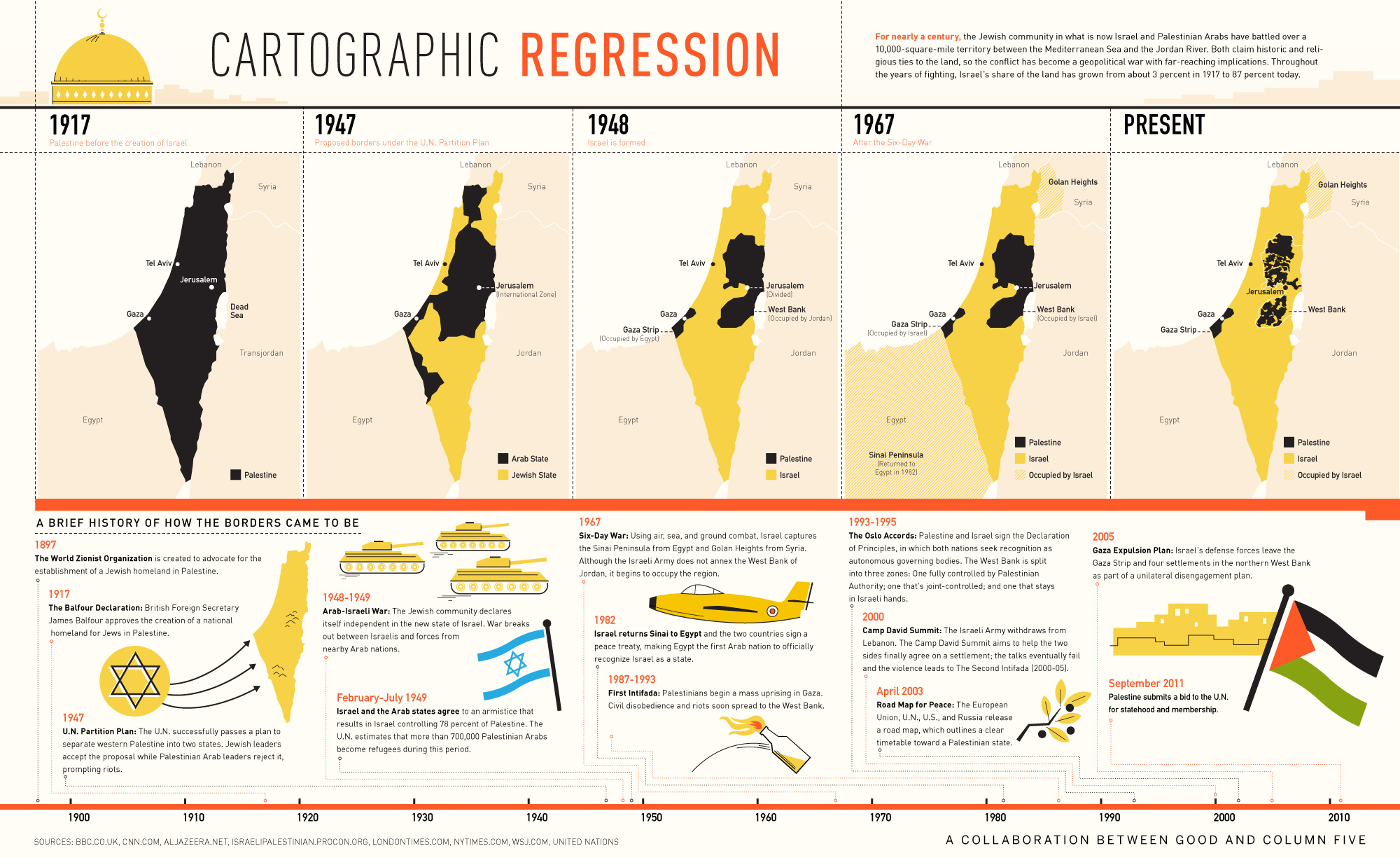
Above: Click here to see a larger view of this map which also includes a brief history of the changing borders in Palestine.
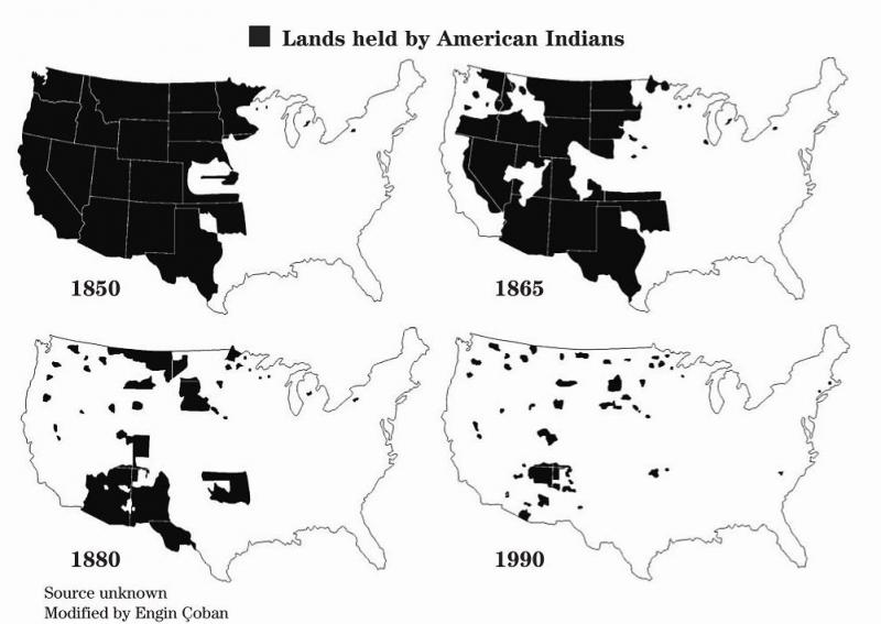
Above: Many people have noted the similarities between the ethnic cleansing that American Indians were subjected to during the colonization of North America and the events in Palestine over the last century. Today there is growing solidarity in action between American Indians and Palestinians. See the video and statement at a demonstration during the United Methodist General Conference 2016 and Palestinian actions for and with those protecting land and water at Standing Rock in North Dakota.
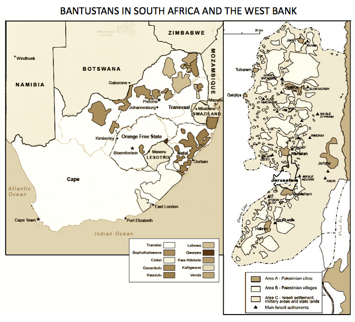
Above: Many comparisons also have been made between the bantustans to which black South Africans were confined during that country’s apartheid era and the fragmented communities that Palestinians have now in the West Bank, similarly created by systemic colonialism and racism – a system of apartheid.
Clearly such fragmentation of their land and of their communities was not intended – then or now – to facilitate a cohesive, viable homeland for either peoples; rather it is a method of controlling an oppressed people and fully exploiting/colonizing the territories to which they have lost access.
The South Africans understand too well what is happening to the Palestinian people and South African leaders have testified to what they have identified as apartheid – worse than they experienced in South Africa – on their visits to occupied Palestinian territory. In 2009, the South African government commissioned a study by an international team of legal analysts to determine if the Israeli occupation regime met the legal criteria for the crime of apartheid under international law: The International Convention on the Suppression and Punishment of the Crime of Apartheid, which was adopted by the United Nations General Assembly in 1973. See the results of that study here.
All Map Pages:
• Maps “home page” includes map of The Middle East
• Ottoman Empire through 1949
• 1967 to the present
• Jerusalem
• Bethlehem (coming soon)
• Area C/ Jordan Valley (coming soon)
• Loss of Land
See also the collection of maps in the Palestine Teaching Trunk.
Ten Maps to Understand the Occupied West Bank
Since 1967, Israel has occupied the West Bank. Here are 10 maps showing how military control affects Palestinian lives.

Mohammed Haddad and Marium Ali, Aljazeera, 16 Sep 2024
As Israel’s war on Gaza, which has killed more than 41,000 people, nears one year, assaults in the occupied West Bank continue, with at least 703 people killed by Israeli forces since October 7.
Despite Gaza and the West Bank being just 33km (21 miles) apart at their closest points, Israeli restrictions have long prevented travel and interaction between the two Palestinian territories, even before the recent conflict.
To better understand the effect of these restrictions and the situation on the ground, here is a visual overview of the geography, history and living conditions of the millions of Palestinians in the West Bank.
1 – How big is the occupied West Bank?
The West Bank, including occupied East Jerusalem, covers a land area of 5,655sq km (2,183sq miles), making it about 15 times larger than the Gaza Strip, spread over 365sq km (141sq miles).
Compared with other places around the world, the kidney bean-shaped West Bank is roughly the same size as Delaware in the United States or Bali in Indonesia. It is about half the size of Northern Ireland in the United Kingdom and approximately a third of the size of Gauteng province in South Africa.

2 – How did the West Bank get its name?
The West Bank, called al-Daffah in Arabic, is located on the western side of the Jordan River, from which it derives its name.
The 251km (156 miles) long river flows from the Lebanese mountains to the Dead Sea, adding fertile soil to the surrounding valley. The Jordan Valley makes up 30 percent of the West Bank and constitutes half of its agricultural land.
Due to tight Israeli controls and restrictions, Palestinians do not have their own airport. Instead, to travel in and out of the West Bank, Palestinians with the necessary permits must use the King Hussein (Allenby) Bridge over the Jordan River to reach Jordan and onward destinations.

3 – How many people live in the West Bank?
The West Bank, with approximately 3.3 million Palestinian inhabitants, has roughly one million more residents than Gaza.
The West Bank is divided into 11 governorates. Hebron, or al-Khalil in Arabic, is the most populous governorate with about 842,000 residents. It is followed by Jerusalem (500,000), Nablus (440,000), Ramallah and el-Bireh (337,000) and Jenin (360,000).
Additionally, about 700,000 Israelis live in illegal settlements on Palestinian land. More on Israeli settlers later.

4 – Israeli occupation of the West Bank
Since 1967, Israel has maintained a military occupation of the West Bank, involving arrests, checkpoints, home invasions, demolitions and frequent raids and assaults.
To better understand the daily struggles Palestinians face under Israeli occupation, take a look at this illustrated guide.
In the past 12 months, Israel demolished at least 1,697 Palestinian structures, primarily homes, displacing 4,233 people, according to United Nations figures. This amounts to an average of five structures destroyed per day.
The figures for 2024 represent the highest number of structures destroyed in one year since the UN began tracking in 2009.
Over the past 15 years, Israel has demolished at least 11,500 Palestinian-owned structures, with three-quarters of those located in Area C.

5 – The differences between Areas A, B, and C
As part of the 1993 Oslo Accords, signed by the Palestine Liberation Organization (PLO) and Israel, the occupied West Bank was divided into three areas – A, B and C.
The Oslo Accords represented the first direct Palestinian-Israeli peace agreement. This led to the formation of the Palestinian Authority (PA) – an administrative body that would govern Palestinian internal security, administration and civilian affairs in areas of self-rule, for a five-year interim period.
Area A initially comprised 3 percent of the West Bank and grew to 18 percent by 1999. In Area A, the PA controls most affairs.
Area B represents about 22 percent of the West Bank. In both areas, while the PA is in charge of education, health and the economy, the Israelis have full control of external security, meaning they retain the right to enter at any time.
Area C represents 60 percent of the West Bank. Under the Oslo Accords, control of this area was supposed to be handed over to the PA. Instead, Israel retains total control over all matters, including security, planning and construction. The transfer of control to the PA never happened.

6 – Illegal Israeli settlement expansion
Israeli settlements are Jewish communities built on Palestinian land. Roughly 700,000 Israeli settlers are living in at least 250 settlements and outposts in the occupied West Bank and East Jerusalem.
Israeli settlements are illegal under international law as they violate the Fourth Geneva Convention, which prohibits an occupying power from transferring its population to the area it occupies.
The settler population is growing faster than Israel’s overall population, with about 10 percent of Israel’s 6.8 million Jewish citizens living in these areas. Settlers receive Israeli citizenship and government subsidies that lower their cost of living.

7 – Israeli separation wall and checkpoints
Since 2002, Israel has been constructing a wall that stretches for more than 700km (435 miles), cutting deep into Palestinian territory.
Israel has also constructed hundreds of road obstacles and checkpoints, severely limiting Palestinian freedom of movement.
While Palestinians may have to wait for hours at these checkpoints and travel along segregated road networks, Israelis can travel freely on their own “bypass roads” which have been built on Palestinian land to connect illegal Israeli settlements to major metropolitan areas inside Israel.

8 – Occupied East Jerusalem and the Old City
Jerusalem, a city sacred to Muslims, Christians, and Jews, has had West Jerusalem under Israeli control since 1948, with a Jewish majority. East Jerusalem, including the Old City, has been under Israeli occupation since 1967 and is mostly Palestinian.
Since its annexation in 1980, Israel has considered the entire city of Jerusalem a part of its territory. This is not internationally recognised. For this reason, Israeli maps do not show East Jerusalem a part of the occupied West Bank.
The Old City, located in East Jerusalem, is home to some of the holiest sites in Islam, Judaism and Christianity. The area, which is smaller than 1sq km (0.39sq miles), is home to Al-Aqsa Mosque, the Western Wall, St James Cathedral and the Church of the Holy Sepulchre, among others.

9 – Palestinian refugee camps
The West Bank is home to at least 870,000 registered refugees, with about 25 percent living in 19 camps established after the 1948 Nakba.
On May 14, 1948, the British Mandate expired and Zionist leaders announced they would be declaring a state, triggering the first Arab-Israeli war.
Zionist gangs expelled some 750,000 Palestinians and captured 78 percent of the land. The remaining 22 percent was divided into the West Bank and the Gaza Strip.
Some 1.5 million Palestinian refugees are living in 58 official UN camps located throughout Palestine and neighbouring countries. In total, there are at least 5.9 million registered Palestinian refugees mostly living outside of these camps.
The plight of Palestinian refugees is the longest, unresolved refugee problem in the world.

10 – Israeli assaults on the West Bank
Since launching its severest raids in two decades on August 28, Israeli forces have killed at least 50 Palestinians across the West Bank.
The assaults involved hundreds of ground soldiers advancing in bulldozers and armoured vehicles, supported by fighter jets and drones that dropped bombs.
